
SGL LH D5: 2250m climb and then some!
S:5 R: 0 to 5 H:3.
C: Epic climb, but do the tunnel.
My 2nd time cycling to the top of this peak and my 5th over the Nu (Hengduan) mountain range.
The first time was about 10 years ago, when I put my bike on a donkey and hiked and camped a night, then went back over the southern hill roads. The 3rd time was to the top from the Mekong about 4 years ago, and just 2 days ago, I managed the mid-tunnel route. Each climb is quite different, and I still want to go back.
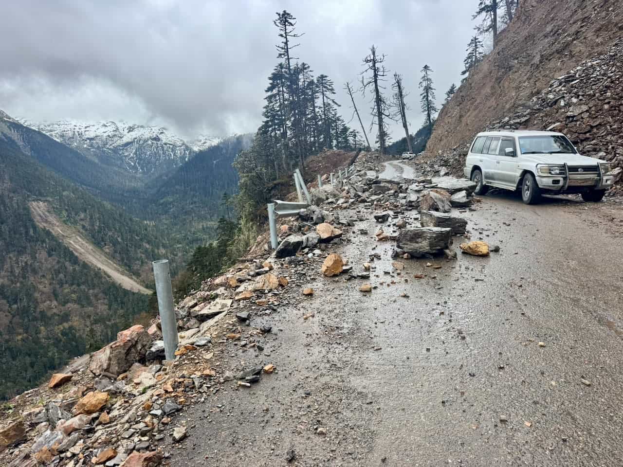
The day started easily enough, following the river for 15km or so, and then turns East and the climbs then goes on for 50km 2250m to the top Kongqur Mountain pass. You’re basically cycling through one of the most biodiverse parts in the world and get to see different Altitudinal zonations along with it. Bring enough water, as only one stop at the top or through the tunnel. The last 5km or so to the top you cannot currently drive, locals rent out their 4wd, but they let you cycle it. It’s a landslide mess, I guess each snow melt washes it away. This time, I was not rewarded with amazing views from the top,, but last time, from the other side, I was. I put on warm clothes for the downhill, bought some drinks, and got down as quickly as the road would allow. The first section before the tunnel was terrible but great views, then after it was easy and quick enough. There are no places to stay or eat on the Nu side,, but there are two or three small villages 1/3 of the way up on the Mekong side.
Once I hit the Mekong road junction, it was about 4pm and I got myself a good feed, shed clothes, and got on my way again. There seems to be a continuous tailwind (from the south) along the river valley. I got caught out going the other direction 10 years ago. Be warned! Anyway, the road starts off as a gentle climb and then the last + 20km 1000m… gets steeper and steeper. The last 400m up through the town was a cruel….
Not much is going on in Deqen, a transit town or an overnight stop to see Meili Mountain. A good feed and a good day. It really amazes me how different in feeling, culture, and enviorment how different these two valleys are. The Nu is warm, moist with a strong “tropical feel” more influenced by the south? The Mekong is dry, windy, with a strong Tibetan feel to it, with more influence from the North?
这是我第二次骑车登上这座山峰,也是第五次穿越涇河(横断)山脉。
第一次大约是10年前,当时我把自行车捆在驴背上,徒步上山露营了一晚,然后从南侧的山路折返。第三次是约4年前从湄公河畔骑上山顶,而就在两天前,我成功走完了隧道中段路线。每次攀登都别有风味,我依然想重游此地。
这一天的行程起初相当轻松,沿着河流骑行约15公里,随后转向东行,接着便是长达50公里、海拔上升2250米的爬坡,直至孔曲山口。你基本上是在骑行穿越世界上生物多样性最丰富的地区之一,并能沿途观察到不同的海拔带。请务必带足饮用水,因为沿途只有在山口顶部或穿过隧道时才有补给点。通往山顶的最后5公里左右路段目前无法驾车通行,当地人会出租他们的四驱车,但允许骑行通过。那里是一片山体滑坡造成的乱象,我想每次融雪都会冲刷掉部分路基。这次,我没能从山顶欣赏到壮丽的景色,但上次从另一侧下山时,我确实看到了。我换上保暖衣物准备下坡,买了些饮料,然后以道路允许的最快速度冲了下去。隧道前的路段状况极差,但风景绝佳;穿过隧道后则轻松快捷。努河(Nu)一侧没有住宿或餐饮场所,但在湄公河一侧,沿途三分之一处有两三个小村庄。
抵达湄公河路口的时辰约莫下午4点,我饱餐一顿,脱下厚衣,随即继续上路。沿着河谷似乎总有股持续的顺风(来自南方)。十年前我反向骑行时曾因此吃过苦头。请务必注意!总之,道路起初是缓坡,但最后20多公里要爬升1000米……坡度越来越陡。穿过镇子最后那400米的爬坡简直是种折磨……
德钦没什么特别的,只是个中转小镇,或是去梅里雪山途中的过夜点。吃得饱饱的,过得挺好。这两条河谷在氛围、文化和环境上的差异真的让我惊叹。怒江温暖湿润,带着浓厚的“热带风情”,受南方影响更深?湄公河则干燥多风,充满浓郁的藏族风情,受北方影响更深?


Supporters: A great thanks to the companies and individuals who support me; wildhomestay for my logistics, Specialized for my bikes, SRAM for my components, Coros for my gps navigation, rekkiworks for my custom luggage, chinabasetravel for my Tibet travel support and Outopia, thenorthface, and lululemon for my apparel & gear!
Other Posts from the Trip:


Tibet Cycling Guide 给外国游客的西藏骑行简要介绍。

Last Pass, Monistry & Lhasa
50 30 Perfection

D18 Bumps to Xincou Lake

Lunang to Basongcou

SGL LH D14: Wales to Switzerland

SGL LH D12: To Lake Ranwu

Gama La Pass & 72 Turns

Tongda La Pass

Hong La Pass

Enter Tibet

Up & Up, Down & Up

The 3 Rivers in a Day
